|
Saturday |
B R Y A N V I K I N G S |
|
FIELDS
|
BallCharts.com/VikingMenSoccer |
Attendance:
Bryan
TX
USA

Directions to Texas High Schools
From Bryan High School
A&M Consolidated High School, 701 FM 2818, College Station, TX 77840. (979)764-5500
Take Briarcrest east to Earl Rudder Frwy/Hwy 6. Turn right (south). Travel to College Station. Exit
Emerald Parkway. Turn right at the stop sign onto Harvey Mitchell Pkwy South. Stay on Harvey Mitchell
through four lights. At the fourth light, turn right at the intersection of Welsh and Harvey Mitchell. The
high school gym is on the right and the football and baseball fields are on the left.
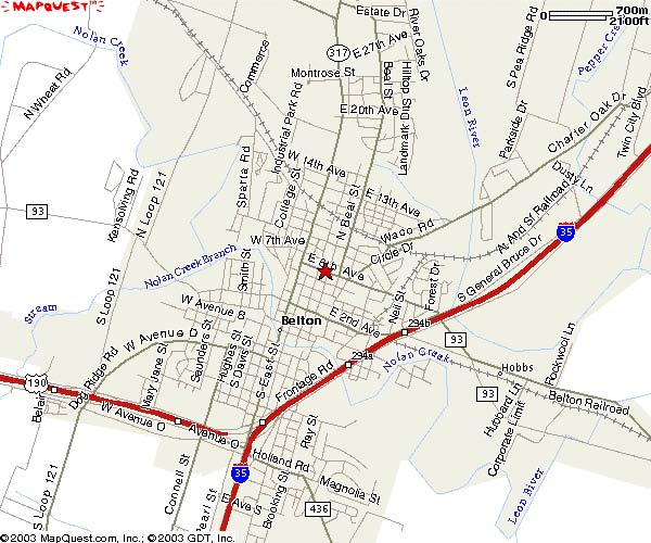
Wilson-Kerzee Field - Belton
612 East 6th (76513)
From Temple High School take I-35 South. Once in Belton take the 6th
Street Exit. Take a right on to 6th Street. Travel on 6th Street about 2 miles
and Wilson-Kerzee Field (Old Tiger Stadium)will be to your right.
Belton High School, Tiger Stadium, 600 Lake Road, Belton, TX 76513. (254)933-4600
Take Briarcrest Drive east to Earl Rudder Frwy/Hwy. 6. Turn left (north). In Hearne, take a left onto Hwy
79/190 and go to Milano. In Milano, turn right onto Hwy. 77 to Cameron. In Cameron take Hwy. 36/190
northwest approximately 40 miles. On Hwy. 36/190 south of Temple, take Hwy 93 west just past
Heidenheimer at the blinking light. Hwy 93 will bring you into Belton at I-35. Hwy. 93 becomes 6th Street
after you crossover I-35.When you come to a stop light at the T-intersection, turn right onto North Main.
Continue approximately 2 miles. You will make a left on Lake Rd./Hwy 439 and Belton HS will be on your
left (about 1 mile). The football field is behind the school.
Alternate directions to Belton High School: Take Hwy 6 to the north side of Hearne and take a left on FM
485, continue on until you reach 53 (approximately 40 miles). At the flashing light, turn left. This will
turn into Adams Street in Temple. Stay straight until you reach I-35. Go south. Continue until you reach
Ave. 6th, exit and turn right. 6th Street, dead ends into Main Street, turn right. Once you pass the Wal-
Mart on the left, look for Lake Road. At the light, turn left (convienence store on right). School is at the
next light on the left, turn left and then turn right into the parking lot, gym is in the back.
Conroe High School
Take Hwy 6 south to Navasota. Exit 105 and turn left to Conroe.
http://www.conroeisd.net/about/maps/05_06%20District%20Map2%20ltr.pdf
Copperas Cove HS, 400 S. 25th Street, Copperas Cove, TX 76522 (254)547-2534
Take Hwy 6 to Hearne. In Hearne, go west on Hwy 79 towards Austin. In Milano, turn right on Hwy 36
and go north. . On Hwy. 36/190 south of Temple, take Hwy 93 west just past Heidenheimer at the
blinking light. Hwy 93 will bring you into Belton at I-35. Take a left and merge onto I-35 (south) to exit
293A (Hwy 190). Take Hwy 190 through Harker Heights and Killeen - all the way to Copperas Cove
(approximately 25 miles).
Choice 1:
Turn right on Main Street and go a few blocks to Avenue E. Turn left on Avenue E and continue
until you get to 25th Street. The high school is located at 400 S. 25th Street.
Choice 2:
When entering Cove, stay in the far right lane. Continue to the second light and take a right at
Avenue D. Go through one traffic light and two four-way stop signs. Turn left onto 7th Street.
Go to the stop sign and turn right onto Avenue E. Continue on Avenue E to 25th Street and
Copperas Cove High School will be on the right.
Copperas Cove Football Stadium
Take Hwy 6 to Hearne. In Hearne, go west on Hwy 79 towards Austin. In Milano, turn right on Hwy 36
and go north. . On Hwy. 36/190 south of Temple, take Hwy 93 west just past Heidenheimer at the
blinking light. Hwy 93 will bring you into Belton at I-35. Take a left and merge onto I-35 (south) to exit
293A (Hwy 190). Take Hwy 190 through Harker Heights and Killeen - all the way to Copperas Cove
(approximately 25 miles). Turn left onto MLK (by the 7-11 convenience store. MLK will make a sharp left
angle) and then right on Williams Road. The stadium will be on the right (approximately 2 or 3 blocks).
Cy-Falls High School, 9811 Huffmiester, Houston, TX 77095. (281-856-1000)
Take Hwy 6 south to Houston. Exit Huffmiester and take a right. The school is located several miles
down and on the right. Map located at: http://www.cfisd.net/aboutour/distmap.htm
Cy-Ridge High School, 7900 N. Eldridge Parkway, Houston, TX 77041
Take Hwy 6 to Houston. It will become 290. Exit Eldridge Parkway and turn right. School is on the left
across from Traders Village. Map located at: http://www.cfisd.net/aboutour/distmap.htm
Georgetown
Take Hwy 6 north to Hearne. In Hearne, take a left onto Hwy 79/190 and travel to Round Rock. Take a
right and enter onto I-35 and travel north to Andice Road exit in Georgetown. Exit. Turn right at 1st stop
(Andice goes to the left, but you want to turn right.) Get into the left lane. Turn left on Austin Avenue
(at light) and follow it to the school on the right. The 9th grade campus is directly past the high school.
Harker Heights, 1001 FM 2410, Harker Heights, TX 76548 (254-501-0800)
Take Hwy 6 to Hearne. In Hearne, go west on Hwy 79 towards Austin. Go approximately 20 miles west
on Hwy 79 to Milano. In Milano, take a right on Hwy 36 and head north for approximately 40 miles. After
you pass through Heidenheimer, take a left on US 190. This will take you into Belton. Once in Belton,
you will get back on I-35 and head south for approximately 1 mile and take the 190 exit (Exit #293A) to
Harker Heights/Killeen. Stay on 190 West for approx. 12 miles. Once in Harker Heights, take Indian
Trails/FM-2410 Exit and take a left (south) on Indian Trails/FM-2410 at the traffic light to cross over Hwy
190. Continue approximately 1.5 miles. HHHS will be on the left at the corner of Verna Lee and FM 2410.
Katy Rhodes Memorial Stadium
Take Hwy 6 South to Hempstead. Merge (over the bridge) onto Hwy 290 and take the first exit to
Brookshire. After you exit at the stop sign go straight through. Do not re-enter Hwy 290! The
feeder road will curve to the right. Continue on FM 359 to Brookshire. At Brookshire, take a left onto
Hwy 90. Go approximately ! mile and take a right (FM 359 South). Take a left onto I-10 and go
approximately 7 miles to Katy-Ft. Bend County Road (at Katy Mills Mall and the Water Tower). Go left
(under I-10) and head north until you get to Rhodes Memorial Stadium on the left.
Alternate Directions to Rhodes: Hwy 6 South to Hempstead, Hwy 290 towards Houston, after the
Badtke exit construction begins, get in the right lane & look for Katy-Hockley Road to the right. (this is
right at the new underpass, but it is not yet open) Katy-Hockley winds left and right a few times, then
straightens out for a long stretch. Stay on Katy-Hockley all the way until you get to Morton Ranch Road,
you will veer to the right, then back left back onto Katy-Hockley Road. Go to the next light & turn left on
Franz Road, go down a block & turn right onto Katy Fort Bend County Road. The stadium is off to the
right, which is the visitors side.
Killeen Shoemaker H.S.
3302 Clear Creek (76549)
From Temple High School take I-35 South. Take the Hwy 190 West exit to
Killeen. Continue on Hwy 190 through Killeen and take the Clear Creek
Road exit. At the intersection, take a left and stay on Clear Creek Rd. (Stan
Schlueter Loop) for about 2 miles. Shoemaker H.S. will be on the left.
For more
Killeen (Leo Buckley Stadium)
Take Hwy 6 to Hearne. In Hearne, go west on Hwy 79 towards Austin. Go approximately 20 miles west
on Hwy 79 to Milano. In Milano, take a right on Hwy 36 and head north for approximately 40 miles. After
you pass through Heidenheimer, take a left on US 190. This will take you into Belton. Once in Belton,
you will get back on I-35 and head south for approximately 1 mile and take the 190 exit (Exit #293A) to
Harker Heights/Killeen. Stay on 190 West for approximately 26 miles. When you get to Killeen, exit on
W.S. Young Drive and make a right, stay on W.S.Young Drive for about 1 ! - 2 miles passing a few
traffic lights. When you get to Business 190/Veterans Memorial, McDonalds to the left and Hastings
Records to the right that is Business 190/Veterans Memorial, make a right there and go to the first
traffic light which is 38th Street and make a left. You will see the school from there, its about " mile
and make a right after the school the stadium is behind the school. The schools address is 500 North
38th Street. Map of district: http://www.killeenisd.org/Map-Web.pdf
Klein Collins High School, Klein, TX
Take Hwy 6 south to Hwy 105 E in Navasota. Exit and turn left towards Plantersville. In Plantersville,
turn right onto 1774 and proceed to Magnolia. In Magnolia (at the dead end) turn right, go over railroad
tracks, and take an immediate left onto 249. In Tomball, turn left on 2920. Follow into Klein. Pass
Kuykendahl, then 2 to 3 lights will be Falvel. Turn right (Shell station) onto Falvel. School is located on
right side. Softball Complex behind school.
Klein Oak High School, 22603 Northcrest Drive, Klein, TX 77379. (832)484-5000
Take Briarcrest east to Earl Rudder Frwy. Turn right (south). Merge onto Earl Rudder Frwy./Hwy 6.
Travel south to Navasota. Exit FM 105, turn left. Continue to Plantersville, turn right on FM 1774 to
Magnolia. At Magnolia take a right at the light, cross the railroad tracks and make an immediate left turn
onto FM 249.Travel FM249 to Tomball. Turn left on FM2920, turn left on Boudreaux, continue on this and
it turns into Spring Stuebner. Turn left onto Northcrest, follow for 1/2 mile and school is on the left.
Travel distance 65 miles. Time depends on traffic.
Leander High School, 3301 S. Bagdad, Leander, TX 78641. (512)435-8000
Take Hwy 6 north to Hearne. In Hearne, take a left onto Hwy 79 and travel to Round Rock. Take a right
onto I-35 and travel north until Cedar Park exit. Exit and turn left (over I-35). Continue approximately 9
miles until you get to Bagdad Road. Take a right onto S. Bagdad Road. A.C. Bible Stadium will be on the
corner of S. Bagdad and New Hope Road.
Mary Hardin Baylor, Belton, TX
Take Hwy 6 to the north side of Hearne and take a left on FM 485, continue on until you reach 53
(approximately 40 miles). At the flashing light, turn left and continue to Temple. Stay straight until you
reach I-35. Go south (left). Continue until you reach Ave. 6th, exit and turn right. 6th Street, dead ends
into Main Street, turn right onto Main. Take a left onto 9th Avenue until you reach the campus. (You will
go by the Presidents home and stay to the right to the Mayborn Campus Center on College Street).
Map located at: http://www.umhb.edu/vtour/map/newinteract800.htm
Pflugerville
Take Hwy 6 north to Hearne. In Hearne, take a left onto Hwy 79 and travel to FM 685 just before you
get to Round Rock. Turn left onto FM 685 and go to FM 1825 (at the dead end). Turn right on FM 1825
and follow it to the school on the left.
Round Rock
Take Hwy 6 north to Hearne. In Hearne, take a left onto Hwy 79/190 and travel to Round Rock. When
you get to I-35 (do not get on the interstate), turn south on the feeder road and go to first light RR620.
Turn right (west) on RR620 to Lake Creek Drive. Turn left onto Lake Creek Drive the school is on the
right.
Shoemaker, 3302 S. Clear Creek Road, Killeen, TX 76549 (254-501-0900)
Take Hwy 6 to Hearne. In Hearne, go west on Hwy 79 towards Austin. Go approximately 20 miles west
on Hwy 79 to Milano. In Milano, take a right on Hwy 36 and head north for approximately 40 miles. After
you pass through Heidenheimer, take a left on US 190. This will take you into Belton. Once in Belton,
you will get back on I-35 and head south for approximately 1 mile and take the 190 exit (Exit #293A) to
Harker Heights/Killeen. Stay on 190 West for approximately 26 miles. Once in Killeen, you will take the
Clear Creek Road exit. Take a left (over the overpass) on Clear Creek Rd/FM 3470 and go approximately
1 1/2 miles. The high school will be on the left. Take the first entrance into the school to the stadium.
Map of district: http://www.killeenisd.org/Map-Web.pdf
Spring High School, Spring, TX
Take Hwy 6 south to Navasota. Exit 105 and turn left to Conroe. In Conroe, take I-45 South to the
Louetta Exit in Spring. At Cypresswood, take a left and go under I-45. Stadium is behind the school,
visible from I-45.
Temple High School, Temple, TX Wildcat Stadium
Take Hwy 6 north to Hearne. Go through Hearne to the north side and turn left onto FM 485. Go west
on 485 until it runs into Hwy 53. Take a left of Hwy 53. It will take you into Temple. In Temple, take a
right on 31st Street just before you get to I-35. The high school and stadium will be on your right. The
school is located on the opposite side of the stadium.
Texas A&M University, College Station, Texas
Map located at: http://communications.tamu.edu/visitors/images/Campus_Map_Fall_03.pdf
The Woodlands High School, 6101 Research Forest, The Woodlands, TX 77381
From Briarcrest Drive at Earl Rudder Frwy go south on Hwy 6 to Navasota. Take Hwy 105 exit and turn
left (turn and go under the bridge). Go east to Plantersville to FM 1774. In Plantersville, take a right
onto FM 1774 and continue to Magnolia until it "deadends" at FM 1488. Take a left and head east to The
Woodlands. In the Woodlands, turn right on 242 and go to Gosling Road. Turn right at Gosling Road
and go to Research Forest Drive. Turn right on Research Forest Drive and continue to Cat's Cradle. This
is the entrance.
Tomball High School, 30330 Quinn Road, Tomball, TX 77375. (281)357-3220
From Briarcrest Drive at Earl Rudder Frwy go south on Hwy 6 to Navasota. Take Hwy 105 exit and turn
left. Go east to Plantersville to FM 1774. Turn right (south) and go to Magnolia. In Magnolia, take a
right at the light and then an immediate left (over the railroad tracks) onto FM 249. Go south to Tomball.
Take a left on Baker Street (at the Diamond Shamrock Gas Station). Take a left on Quinn Road and the
stadium is located behind the school.
University of Texas, Austin, TX
Map located at: http://www.utexas.edu/maps/
Waco ISD Sports Complex, 1401 S New Road, Waco, TX 76711-1336
Travel north on Hwy 6 to Waco. Exit Loop 340 and continue several miles (over I-35). Turn right onto
Bagby Avenue about ! mile. Stadium in located on the corner of Bagby and S. New Road (about 2
miles). http://www.wacoisd.org/stadium_map.php
Waco Midway High School, 8200 Mars Drive, Waco, TX 76712. (254)761-5650
Take Hwy 6 north to Waco. Before your reach Waco, take a left onto Loop 340 outside of Waco. Go
several miles around loop to I-35. Take 35 south. Exit Hewitt. Go right. Go through 3 lights, cross
railroad tracks and take right on Hewitt Lane/Drive. Go to Midway HS (on right) and turn right onto
Panther Way and circle around to get to baseball/softball fields.
Waco High School, 1850 Lake Air Drive, Waco, TX
Take Hwy 6 north to Waco. Head South on I-35(L). Once on 35, exit Valley Mills and turn right, go
down (over a bridge) and turn right onto New Road. The high school will be down a couple of lights on
the left off of Lake Air Drive. (Approximate time: 1 hour and 45 minutes)
Map available at: http://www.wacoisd.org/district_maps.php
Waco Paul Tyson Stadium
Take Hwy 6 north to Waco. Head South on I-35(L). Once on 35, exit Valley Mills and turn right, go
down (over a bridge) and turn right onto New Road. The high school will be down a couple of lights on
the left off of Lake Air Drive. Stadium located behind high school. (Approximate time: 1 hour and 45
minutes) Map available at: http://www.wacoisd.org/district_maps.php (Waco HS is #30 on the map)
Houston Area Football Stadiums


 Free Team Pages,
Free League Pages
Free Team Pages,
Free League Pages
Powered by BallCharts.com - free team & league websites